
KAL Flight 801 - Animation Summary
Disclaimer:
| University of Bielefeld - Faculty of technology | |
|---|---|
|
Networks and distributed Systems
Research group of Prof. Peter B. Ladkin, Ph.D. |
|
| Back to Abstracts of References and Incidents | Back to Root |
| This page was copied from: http://www.ntsb.gov/events/kal801/anim_summary.htm | |
![]()
KAL Flight 801 - Animation Summary
Disclaimer:
This reconstruction was developed using digital flight data recorder information, cockpit voice recorder information, recorded radar data, approach plate information and recorded weather data. This depiction does not represent actual weather or visibility conditions at the time of the accident.
 QuickTime
animation of last 64 seconds of flight [5M]
QuickTime
animation of last 64 seconds of flight [5M]
Summary:
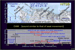
The animation depicts a top and side view of the topography of Guam for the flight path of the airplane within a 12 nm x 4 nm area, from 12 nm out from Runway 06L threshold for FL801 on approach to Agana A/P. The top view is to scale (in nautical miles) for both the x and y axes, and is oriented so that the x axis parallels the centerline of Runway 06L and the y axis is perpendicular to the runway centerline, with distances measured from left and right of the runway. The side view is displayed at an expanded vertical scale with each horizontal line representing 200 feet MSL altitude. The y axis is MSL altitude divided by 100, in feet. The x axis coincides with the x axis for the top view and is in nautical miles. An abbreviated-verbatim CVR transcript is displayed between the top and side views, with text appearing in groupings for readability and for as near as possible real time display. Time is displayed as local time in the top view.
Top View: Both the x and y axes are nm. The top view shows the approach of FL801 from the north and west of Guam, intercepting the localizer near the Flake intersection and continuing in towards Runway 06L at Agana A/P. The locations for Flake Intersection, Outer Marker, DME VOR, and Middle Marker are displayed in this view. The localizer full fly left/right limits are also displayed here.
Side View: The side view displays the topographical profile of the island along an extended centerline from the runway, from 12 nm miles from the runway threshold towards approach to 2 nm in the opposite direction. The side view indicates the step altitudes for the approach, as shown for 2600, 2000, 1440, and 560 feet, respectively. A simulated ARTS II MSAW Alert (initiating at 64 sec before impact and at 1700 feet MSL altitude) is also displayed. Distances along the extended centerline from the DME VOR to the Flake Intersection, Outer Marker, and Middle Marker are also displayed. A glide slope is not displayed since it was not usable at the time of the accident.
| This page was copied from: | http://www.ntsb.gov/events/kal801/anim_summary.htm |
| COPY! | |
| COPY! | |

|
by Michael Blume |