Networks and Distributed Systems
Research group of Prof. Peter Bernard Ladkin, Ph.D.
Traditional Aviation Radio Navigation: An Introduction
Peter B. Ladkin
Article RVS-J-97-06Abstract: I describe the basics of aircraft land-based radio navigation with VOR and NBD reception equipment.
Contents
- Introduction
- Magnetic and True North, and Elementary Navigation
- VORs, NDBs, ILS's, Localizers, Glide Slope and All That Stuff
- NDB
- NDB Navigation
- VORs
- ILS, Localiser and Glideslope
- An On-line List of all U.S. Navaids
- References
Introduction
Back to Contents
Analysing and understanding aviation procedures requires a knowledge
of aerial navigation, and in particular the ground devices and
on-board instruments that support it. In the beginning, there was the
compass. Then certain instruments were devised which
could `home in' on a radio signal, that is, could indicate in which
direction relative to the aircraft a given radio signal was coming
from. The radio transmitters that send out such a signal nowadays are known
as Non-Directional Beacons (NDBs). Since the Second World War,
ground-based radio transmitters which give an aircraft accurate
position information, the VHF Omni-Range, or VOR, transmitters,
have formed the basis of terrestrial support for overland aerial
navigation. Finally, an aircraft coming in to land using an
instrument approach procedure may use an Instrument Landing System
(ILS), which consists of Localizer and Glideslope (GS)
transmitters, as well as a number of Marker Beacons and
even Compass Locators. What are all these things, and how
do they aid navigation? I had better start with a word or two on
how the earth is divided up into a navigation grid.
Magnetic and True North, and
Elementary Navigation
Back to Contents
What are true and magnetic north? True north is the direction (from wherever you're standing) in which the North Pole lies. The North Pole is one end of the axis about which the earth is spinning. Magnetic North is the direction in which the Magnetic North Pole lies. The earth generates a magnetic field - that is, the earth acts as a large magnet - and the Magnetic North Pole is where one end of this magnet is. The other ends of the spin axis, respectively the magnetic axis, are called True, respectively Magnetic, South. They are distinguished because, wherever you are standing on the earth's surface, the direction of True North and the direction of Magnetic North are mostly different! The difference is called the magnetic variation and is shown on most aeronautical charts. On the West Coast of North America, the contour-lines of variation lie roughly perpendicular to the coastline. In San Francisco, for example, the difference is 16° east. In Monterey, 73 nautical miles south, it is already only 15° 30' east. (30' is 30 minutes - a degree is subdivided into 60 minutes.) In Los Angeles, it is 14° east. In Vancouver, it's (almost) 21° east (that's what (CanFS) says -- the chart in fact shows the contour running 19 miles NW of the airport, an a NW-SE direction, so I presume it's more like 20°40'E). In London, England on the other hand, the variation contour lines run north of north-north-east. The mouth of the Thames is 4° west, Oxford is 5° west, and Heathrow airport is in between, but my Pooley's Guide (Poo), which has everything else, doesn't tell me the variation (the chart gives it to within one degree, and knowing the variation to fractions of a degree is not particularly necessary or helpful in flight, as (CanFS) also shows).
A compass stably indicates magnetic north. It cannot reliably be calibrated to indicate true north because, as we have seen, the difference is different, depending on where we are flying. Vancouver is less than a two-hour trip by jet from San Francisco, and somewhat over six hours in my slow Piper Archer, and the difference in variation (or the variation in the difference, if you will :-) is already 6°30'. Just about a degree per hour in my Cherokee, just under 4° per hour in your B747, flying perpendicular to the contours. While latitude and longitude, standard position on the earth's surface, is given by a grid oriented on true north and shown so on maps, aircraft compasses orient themselves with respect to magnetic north, and while flying one should keep the difference in mind.
So, suppose one departs San Francisco airport (SFO to the NOAA, KSFO to Jeppesen and international flyers) to visit the airshow at Abbotsford, Canada, just east of Vancouver. One would be flying due north, since KSFO is N37°37'14"W122°22'49" (AFD), and CYXX (Abbotsford) is N49°01'31"W122°21'48" (CanFS). (CYVR, Vancouver International, is N49°11'38"W123°11'04".) The `N' figure here is to be read as degrees-minutes-seconds North of the equator in latitude, and the `W' figure is to be read as degrees-minutes-seconds in longitude West of the former Royal Observatory in Greenwich, London, England, where they started all this nonsense centuries ago (the Royal Observatory is now in Cambridge, but the building in Greenwich still stands). So it looks as if by flying due north you'd miss Abbotsford by one minute one second, to the west (that's the difference in the `W' figures for KSFO and CYXX). What is this distance in terms of miles or kilometers?
A degree of latitude is always 60 nautical miles on the surface. In fact, that's where the term nautical mile is defined, and where it came from - it's one minute of latitude (or longitude at the equator). Of course, since the earth is not quite round, for exactitude it matters precisely where this is measured, but for aerial navigation it doesn't matter. One nautical mile (nm) is one minute of latitude and that's that. It's 1.15 statute miles, that is, about 7/6 of a mile, or 1,852 meters. That makes a second (a sixtieth of a minute) to be about 31 meters. (For those who measure non-metrically, a meter is about 39 inches, that is, 3.25 feet or 1.08 yards.) That makes a second about 31 meters, or about 3 seconds if you're Donovan Bailey. On the equator, a degree of longitude is also 60nm, but the lines of longitude always travel due north, and they all meet at the North Pole. This means that the further north you go from the equator, the closer the lines of longitude are scrunched together, until the separation at the North Pole is nothing. So how tight do they scrunch?
Up in Abbotsford (about 49° north latitude), a degree west is 39nm; in San Francisco (about 38° north latitude), a degree west is about 48 nautical miles. So you can tell from the coordinates that flying due north from KSFO to Abbotsford, you'd travel 11°34'24", or 694.4nm, and you'd miss Abbotsford by 1.3nm to the west of the aerodrome, too close to land on its east runway 07 without acrobatics, but almost good enough for a straight-in approach to its north-facing runway 01. So, do you take off from KSFO and fly a compass heading of 0° for 6 hours (my Archer), or for 1.5 hours (a B747) or for 20 minutes (an SR-71) to get there? You most certainly do not. Remember that magnetic variation. You start off flying a compass course of 346° (remember, 14° east variation) because your compass points to magnetic north.
But then a little less than an hour later (in the Cherokee, 13 minutes later in the B747 and 3 minutes in the SR-71) you had better be flying 345°, an hour later another degree left, and so on, until by the time you reach Abbotsford, to be that 1.3nm west, looking for a straight-in to Rwy 01, you had better be flying 339° on your compass - and then forget the straight-in, you had better make a 30° right turn to land on Runway 01, because its name `01' means it lies somewhere between 006° and 15° magnetic (`24' would mean it would lie somewhere between 236° and 245° magnetic, and so on - its name is constructed from magnetic-heading-to-nearest-ten-degrees with the zero missing).
Now, I want to talk about what you did (the actual path flown by your airplane) and what you wanted to do (fly a straight line for 694nm to an airshow) and point out a difference. So I'll need two different names for what you did and what you intended to do. The actual line you make across the earth's surface is called your track:
TRACK- The actual flight path of an aircraft over the surface of the earth. (PCG)or, defined by ICAO,
TRACK [ICAO]- The projection on the earth's surface of the path of an aircraft, the direction of which path at any point is usually expressed in degrees from North (True, Magnetic or Grid). (PCG)One should distinguish track from course:
COURSE-So the difference between course and track is the difference between your intentions and reality! This is actually quite an unavoidable distinction. An autopilot flying a course accurately will tend to oscillate from side to side of the course a little, as it continually corrects slight deviations back to the course. Thus the track would be a mildly wavy line oscillating about the course (which is a straight line).
a. The intended direction of flight in the horizontal plane measured in degrees from north. [...] (PCG)
Using this terminology, if you flew your corrections diligently, you'd be trying to maintain a course of true north, but your track would be a series of imperceptibly gently rightward-bending curves, bending about 1° right every 100nm, punctuated by a 1° left turn every 100nm. (one hour, 12 minutes, 3 minutes, pick your mode of transportation). This is because you're flying a constant magnetic course, which is a slightly bending true course because the variation varies slightly as you go north, and then every so often you're making a 1°-left correction to account for that variation in variation.
But do you really head off at 345° from KSFO? What if there's a 30-knot (nautical-mile-per-hour) west wind blowing off the ocean? You're flying the Archer at 120kts. Flying an airplane is somewhat like boating, in that the aircraft rarely goes exactly in the direction in which it is pointing. If you want to get across the river to the other side directly opposite, you had better point the nose of the boat upstream into the current, else you will drift downstream and reach the other side downstream of where you wanted to land. In an aircraft, if the wind is blowing you from due west, and you wish to go due north, you had better point the nose of your aircraft to the left, into the wind, because the wind will be blowing you to the right, and if you point due north, you will end up way to the right of where you want to be. The direction in which you are pointing is called your heading. What's your heading in order to maintain an initial course of 345°? With this 30kt direct crosswind (wind coming at you perpendicularly like this), flying at 120kt and wishing you had believed that teacher in high school who told you that trigonometry was important, you had better fly at the angle whose tangent is (30/120), that is, a whopping 14° further left, or 331°. So all in all, you're flying 29° further left than what you might have first thought. (You're also going slower over the ground, since trigonometry and Pythagoras's theorem will tell you you're flying square-root(16+1)= 4.12nm through the air for every 4nm over the ground you fly. So your 120kts airspeed translates to 116.4kts over the ground. So instead of going due north by flying 345° at 120kts, you're going due north at 116.4kts by flying a heading of 331° on your compass.
As you can imagine, there are hand-held calculators to do these
calculations for you, but you do need to look at the charts to tell
at the least what the magnetic variation is and how close together
the lines of longitude are where you are. And what if your calculator
stops working? Many pilots also carry a slide-rule, called an
E6B computer to disguise its true nature, precisely because
slide rules don't break or run out of battery power on you.
VORs, NDBs, ILS's, Localizers, Glide Slope
and All That Stuff
Back to Contents
A VOR is a Very-high-frequency OmniRange radio transmitter.
VORs constitute the
backbone of current land-based aerial navigation in the U.S. and Western
Europe. But first, let's start with the NDB because it's a simpler device.
NDB
Back to Contents
An NDB (Non-Directional Beacon) is a radio beacon that broadcasts continuously on a specific frequency. Aircraft on-board radio equipment can determine in which direction from the aircraft an NDB signal is coming. The on-board aerial consists of a simple metal loop which is rotatable. The radio signal induces a current in the loop, as in a normal aerial, but this current is weaker or stronger depending on the orientation of the loop. When the loop is flat-on to the origin of the signal, the signal is strongest. (Think of the loop as the frame of a round mirror. The signal is detected to be strongest when the mirror is reflecting it back at itself.) The official definition is
A L/MF [low- or medium-frequency] or UHF [ultra-high-frequency] radio beacon transmitting nondirectional signals whereby the pilot of an aircraft equipped with direction finding equipment can determine his bearing to or from the radio beacon and "home" on or track from the station. When the radio beacon is installed in conjunction with the Instrument Landing System marker, it is normally called a Compass Locator. (PCG),in which bearing means:
The horizontal direction to or from any point, usually measured clockwise from true north, magnetic north, or some other reference point through 360 degrees. (PCG)Because aircraft can determine from which direction the signal is coming, they can `home in on', fly in the direction of, the signal to arrive at the beacon.
NDBs broadcast in the frequency band of 190 to 535kHz (a `Hertz', Hz, is one cycle per second) and transmit a continuous carrier signal with either 400 or 1020 Hz modulation. An identification signal consisting of three letters in Morse code is also transmitted. The receiver equipment in the airplane is called an ADF (`Automatic Direction Finder'). The indicator consists of a round calibrated dial and a `needle' pointer which points in the direction that the signal is determined to be coming from.
There are two problems with NDBs. First, erroneous signals.
Radio beacons are subject to disturbances that may result in erroneous bearing information. Such disturbances result from such factors as lightning, precipitation static, etc. At night radio beacons are vulnerable to interference from distant stations. Noisy identification usually occurs when the ADF needle is erratic. Voice, music or erroneous identification may be heard when a steady false bearing is being displayed. Since ADF receivers do not have a "flag" to warn the pilot when erroneous bearing information is being displayed, the pilot should continuously monitor the NDB's identification.
(AIM, Section 1-2, Nondirectional Radio Beacon (NDB))
Second, you can only tell the relative bearing of your aircraft to the NDB - that is, the direction in which the NDB lies. Only by comparing this against the aircraft compass heading (as stably indicated by the directional gyroscope) and doing some trivial trigonometry in hisher head can a pilot determine at which (magnetic or true) bearing the NDB lies from the aircraft. This can be illustrated thus:
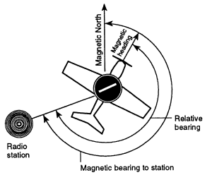
The circular black dial with indicator in the middle of the aircraft is what the pilot sees inside the aircraft.
Some aircraft have an instrument called an RMI (Radio Magnetic Indicator) which incorporates both a directional gyro and the ADF needle so that one can read the magnetic bearing to the beacon directly off the instrument without having to do mental trigonometry.
The service range of an NDB is the distance from the NDB within
which a reliable signal is guaranteed. Service ranges are classified as
15, 25, 50 and 75 nautical miles.
NDB Navigation
Back to Contents
NDB navigation is not necessarily easy. First, there is a course to be flown. Second, the aircraft may be on-course or slightly (or hugely) off-course. Thirdly, the heading of the aircraft may be different from track, to accomodate a crosswind. During an instrument approach, a pilot has to continuously determine all this information, and also calculate and fly corrections. Determining which heading to hold to accomodate a crosswind is an empirical matter. One guesses a heading and determines drift (range of divergence of track from course) and then corrects - first twice as much, to get back onto course, and then when back on course, enough to follow course. All this is quite tricky and one needs to be in practice. This is crucial when flying an instrument approach, since strict adherence to course and altitude restrictions are the only things that guarantee that the aircraft flies clear of obstacles. Anybody who has flown an NDB instrument approach to an airport runway knows how labor-intensive it is. One has to achieve course-following using the above procedure, correcting for probably-changing crosswinds as one descends in altitude, especially in non-level terrain, very accurately and all inside of 2 or 3 minutes.
Use of an ADF in NDB navigation can be illustrated thus:
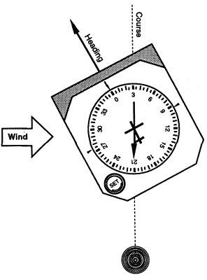
The aircraft is flying on a course directly from the beacon. We don't know what azimuth this course has, but the dial on the ADF is set to straight-ahead=0° (on an RMI, there would be a directional gyro indicator here, not a settable dial). There is a crosswind coming from the left, so a heading correction to the left of 030° must be taken to maintain course in the crosswind. This heading correction shows up on the ADF, indicating that the beacon is relatively at a bearing of 210° behind the aircraft, which means with the heading correction for crosswind, that we are flying on a course with the beacon at a bearing of 180° to our course behind us.
The solution to NDB navigation problems is the VOR.
VORs
Back to Contents
VHF Omni-directional Ranges (VORs) are radio beacons that transmit an signal which contains precise azimuth information, so that upon reception of the signal, an aircraft can tell precisely what bearing with respect to magnetic north the station is from the aircraft (respectively, on what radial the aircraft lies from the station - this is just the reciprocal of the bearing to the station from the aircraft). Such a signal has the advantage that the bearing to the station is read directly off the indicator equipment. `The accuracy of course alignment of the VOR is excellent, being generally plus or minus 1 degree' (AIM, Section 1-3, VHF Omni-directional Range (VOR), paragraph e.1)
Navigating on VOR information is akin to flying on a grid such as the following:
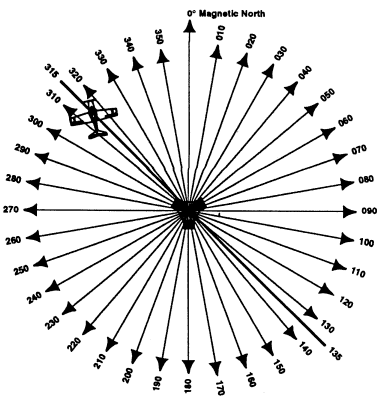
Here, the aircraft is positioned directly on the 315° radial from the VOR. (We do not know on what course the aircraft is flying, although its heading appears to be about 350°.)
Besides being very accurate, the VOR is much easier to use than an NDB. The indicator in the cockpit is a round dial with settable azimuth information, called the Omni Bearing Selector (OBS) and a vertical pendulum-like needle, called the Course Deviation Indicator (CDI) thus:
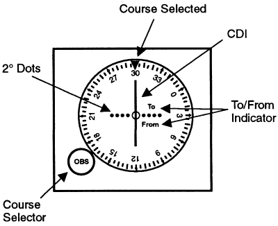
When the aircraft is on the radial set on the instrument (actually, one can set either bearing or radial, depending on which is more meaningful in the situation), the needle points vertically down. When the aircraft has deviated from course, the needle will deviate sideways. A series of dots is shown on the instrument dial so that one can tell how much deviation: `one dot', `two dots', `three dots', `four dots'. A dot is equal to about 2° of deviation. This means that at a distance of 60 nautical miles from the VOR, a one-dot deviation on the CDI indicates that the aircraft is about 2 nautical miles from the selected radial. At 30 nautical miles, one dot would indicate 1 NM of deviation, and so on. When the aircraft is left of course, the CDI needle will deviate to the right, showing the pilot which direction the desired course lies. Similarly, when right of course, the CDI needle will indicate to the left, as in this illustration:
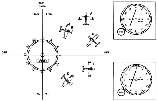
In this diagram, the OBS is set to 0°=360°. An aircraft in position A, B, or C will show a deviation on the CDI as shown to the right (but somewhat exaggerated - the precise number of dots shows a 4° deviation, and the positions A, B, C are indicated much more than 4° to the right of course). Aircraft with 0° set in the OBS, to the south of the VOR in positions D and E, will show a similar deviation. It is important to realise that, unlike with an ADF display, the VOR indicator (OBS and CDI) shows position over the ground with respect to the VOR, and independent of heading or course.
Thus position information along a radial from a VOR is shown directly and accurately on the VOR indicator and there is no need to follow the complicated procedures involved in NDB navigation. One can determine absolute position by tuning two VOR receivers to two different VORs, determining (by centering both DCIs) on what radial from each VOR the aircraft currently lies, and then drawing these two extended radials on the chart on one's knee (the radials are shown on the chart for each VOR, but they don't extend very far from the VOR) to see where they intersect, and that's where the aircraft is!
There are some devices called RNAV (for aRea NAVigation) which integrate such information from two or more VORs to construct a `virtual VOR' on any chosen course, so that to fly this course, one just centers the CDI needle on the indicator, as though there were actually a VOR one is flying towards. RNAVs are nice.
VOR navigation is the major navigation technique throughout much of the world, and certainly in developed countries such as the U.S. and Western Europe. It was developed a half-century ago, after the Second World War.
Technically, VOR operation is achieved by transmitting two signals (actually, there is a continuous carrier with modulation, but let us for the moment consider it as a discrete signal). The base signal is transmitted at regular intervals, let us say time interval T, and in between base signals occurs an azimuth signal. The difference in time between base signal and azimuth signal determines the radial azimuth (from magnetic north) from the VOR that the aircraft is on. When the aircraft is due (magnetic) north of the VOR, the two signals coincide. As the radial angle increases clockwise, the signals become further and further apart. For example, at 90°, the azimuth signal will be at 0.25T; at 180°, at 0.5T; at 270°, 0.75T, until when at magnetic north again, the two signals again coincide.
VOR reception is line-of-sight. `VORs operate within the 108.0 to 117.95 MHz frequency band, and have a pwer output necessary to provide coverage within their assigned operational service volume' (AIM, Section 1-3, VHF Omni-directional Range (VOR), paragraph a). The service volumes are given by the class of VOR:
- T (Terminal): From 1000 feet above ground level (AGL) up to and including 12,000 feet AGL at radial distances out to 25 NM;
- L (Low Altitude): From 1000 ftte AGl up to and including 18,000 feet AGL at radial distances out to 40 NM;
- H (High Altitude): From 1000 feet AGL up to and including 14,500 feet AGL at radial distances out to 40 NM. From 14,500 AGL up to and including 60,000 feet at radial distances out to 100 NM. From 18,000 feet AGL up to and including 45,000 feet AGL at radial distances out to 130 NM.
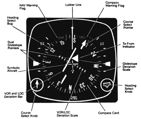
Finally, many aircraft (and most commercial transports) have an instrument that combines a directional gyroscope with a VOR receiver, called a Horizontal Situation Indicator (HSI) and which looks like this:
ILS, Localiser and Glideslope
Back to Contents
To explain the ILS, it is worth quoting significant parts of the AIM.
1-10 Instrument Landing System (ILS)(AIM, Section 1-10, Instrument Landing System (ILS))a. General
1. The ILS is designed to provide an approach path for exact alignment and descent of an aircraft on final approach to a runway.
2. The ground equipment consists of two highly directional transmitting systems and, along the approach, three (or fewer) marker beacons. The directional transmitters are know as the localizer and glide slope transmitters.
3. The system may be divided functionally into three parts:
- (a) Guidance information - localizer, glide slope
- (b) Range information - marker beacon, DME
- (c) Visual information - approach lights, touchdown and centerline lights, runway lights
4. Compass locators [low-power NDBs] located at the Outer Marker (OM) or Middle Marker (MM) may be substituted for marker beacons. DME, when specified in the procedure, may be substituted for the OM.
5. [....]
b. Localiser
1. The localizer transmitter operates on one of 40 ILS channels within the frequency range of 108.10 to 111.95 MHz. Signals provide the pilot with course guidance to the runway centerline.
2. The approach course of the localizer is called the front course and is used with other functional parts, e.g., glide slope, marker beacons, etc. The localizer signal is transmitter at the far end of the runway. It is adjusted for a course width of (full scale fly-left to a full scale fly-right) of 700 feet at the runway threshold.
3. [....Back-course information]
4. Identification is in International Morse Code and consists of a three-letter identifier preceded by the letter I (..) transmitted on the lozalizer frequency.
EXAMPLE:
I-DIA5. The localizer provides course guidance throughout the descent path to the runway threshold from a distance of 18 NM from the antenna between an altitude of 1,000 feet above the highest terrain along the course line and 4,500 feet above the elevation of the antenna sight. Proper off-course indications are provided throughout the following angular areas of the operational service volume:
- (a) To 10 degrees either side of the course along a radius of 18 NM from the antenna, and
- (b) from 10 to 35 degrees either side of the course along a radius of 10 NM [...]
6. Unreliable signals may be received outside these areas.
c. Localiser-type Directional Aid [Describes an installation of a localizer without a glide-slope at an airport]
d. Glide Slope/Glide Path
1. The UHF glide slope transmitter, operating on one of the 40 ILS channels within the frequency range 329.15 MHz, to 335.00MHz radiates its signals in the direction of the localizer front course. The term "glide path" means that portion of the glide slope that interscets the localizer.
[...]
2. The glide slope transmitter is located between 750 feet and 1,250 feet from the approach end of the runway (down the runway) and offset 250 to 650 feet from the runway centerline. It transmits a glide path beam 1.4 degrees wide. The signal provides descent information for navigation down to the lowest authorized decision height (DH) specified in the approved ILS approach procedure. The glidepath may not be suitable for navigation below the lowest authorized DH and any reference to glidepath indications below that height must be supplemented by visual reference to the runway environment. Glidepaths with no published DH are usable to runway threshold.
3. The glode path projection angle is normally adjusted to 3 degrees above horizontal sothat it intersects the MM at about 200 feet and the OM at about 1,400 feet above the runway elevation. The glide slope is normally usable to the distance of 10 NM. However, at some locations, the glide slope has been certified for an extended service volume which exceeds 10 NM.
4. Pilots must be alert when approaching the glidepath intercetpion. False courses and reverse sensing will occur at angles ocnsiderably greater than the published path.
5. Make every effort to remain on the indicated glide path (reference: FAR 91.129(d)(2)). Exercise caution: avoid flying below the glide path to assure obstacle/terrain clearance is maintained.
6. The published glode slope threshold crossing height (TCH) DOES NOT represent the height of the actial glide path on-course indication above the runway threshold. It is used as a reference for planning purposes which represents the height above the runway threshold that an aircraft's glide slope antenna should be, if that aircraft remains on a trajectory formed by the four-mile-to-middle-marker glidepath segment.
7. Pilots must be aware of the vertical height between the aircraft's glide slope antenna and the main gear in the landing configuration and, at the DH, plan to adjust the descent angle accordingly if the published TCH indicates the wheel crossing height over the runway threshold may not be satisfactory. Tests indicate a comfortable wheel crossing height is approximately 20 to 30 feet, depending on the type of aircraft.
e. Distance Measuring Equipment (DME)
1. When installed with the ILS and specificied in the approach procedure, DME may be used:
- (a) In lieu of the OM.
- (b) As a back course (BC) final approach fix (FAF).
- (c) To establish other fixes on the localizer course.
2. In some cases, DME from a separate facility may be used within Terminal Instrument Procedures (TERPS) limitations:
- (a) To provide ARC initial approach segments.
- (b) As a FAF for BC approaches.
- (c) As a substitute for the OM.
f. Marker Beacon
1. ILS marker beacons have a rated power output of 3 watts or less and an antenna array designed to produce an elliptical pattern with dimensions, at 1,000 feet above the antenna, of approximately 2,400 feet in width and 4,200 feet in length. Airborne marker beacon receivers with aa selective sensitivity feature should always be operated in the "low" sensitivity position for proper reception of ILS marker beacons.
2. Ordinarily, there are two marker beacons associated with an ILS, the OM and MM. Locations with a Category II and III ILS also have an Inner Marker (IM). When an aircraft passes over a marker, the pilot will receive the following indications: (See Table 1-10[1]).
Table 1-10[1]
MARKER CODE LIGHT OM --- BLUE MM .-.- AMBER IM .... WHITE BC .. .. WHITE
- (a) The OM normally indicates a position at which an aircraft at the appropriate altitude on the localizer course will intercept the ILS glide path.
- (b) The MM indicates a position approximately 3,500 feet from the landing threshold. This is also the position where an aircraft on the glide path will be at an altitude of approximately 200 feet above the elevation of the touchdown zone.
- (c) The inner marker (IM) wll indicate a point at which an aircraft is at a designated decision height (DH) n the glide path between the MM and landing threshold.
3. [Back course markers...]
g. Compass Locator
1. Compass locator transmitters are often situated at the MM and OM sites. The transmitters have a power of less than 25 watts, a range of at least 15 miles and operate between 190 and 535 kHz. At some locations, higher powered radio beacons, up to 40 watts, are used as OM compass locators. These generally carry Transcribed Weather Broadcast (TWEB) information.
2. Compass locators transmit two letter identification groups. The outer locator transmits the first two letters of the localizer identification group, and the middle locator transmits the last two letters of the localizer identification group.
h. ILS Frequency [Tables]
i. ILS Minimums
1. The lowest authorized ILS minimums, with all required ground and airborne systems components operative, are
- (a) Category I - Decision Height (DH) 200 feet and Runway Visual Range (RVR) 2,400 feet (with touchdown zone and centerline lighting, RVR 1800 Category A, B, C; RVR 2000 Category D).
- (b) Category II - DH 100 feet and RVR 1,200 feet.
- (c) Category IIIA - RVR 700 feet
1-10i1c NOTE.-Special authorization and equipment are required for Category II and IIIA.
j. Inperative ILS Components
1. Inoperative localizer: When the localizer fails, an ILS approach is not authorized.
2. Inoperative glide slope: When the glide slope fails, the ILS reverts to a nonprecision localizer approach.
[....]
An ILS is flown using the CDI needle, with the VOR receiver set to the
ILS frequency. The OBS is not used, although most pilots find it appropriate
to set the localizer inbound course in the OBS. The CDI is more
sensitive than with a VOR, with about one dot per degree deviation.
The glideslope DI is an additional horizontal needle, pivoted on
the left, that shows when the glideslope is received. It indicates
similarly to the vertical CDI - a deviation upwards means `below
glideslope, fly up to recapture glideslope', and a deviation downwards
indicates `above glideslope, descend to recapture glideslope'. When
the localiser CDI lies vertically downwards and the glideslope DI
horizontal, the aircraft is exactly on course and on glideslope.
An On-line List of all U.S. Navaids
Back to Contents
Paulo Santos has developed a WWW site listing all U.S. navaids and airport information (Airnav).
Peter Ladkin
Acknowledgements
Thank you to Arndt Jonasson for comments and corrections.References
Back to Contents(AIM): U.S. Department of Transportation, Federal Aviation Adminstration, Aeronautical Information Manual (AIM), Author, annual. Back
(AFD): U.S. Department of Commerce, National Oceanic and Atmospheric Administration, National Ocean Service, Airport/Facility Directory: Southwest U.S., Author, 16 Sep 1993. Back
(Airnav): Paulo Santos, The AirNav Database, http://www.airnav.com. Back
(CanFS): Geomatics Canada - Géomatique Canada, Canada Flight Supplement: Canada and North Atlantic Terminal and En Route Data, Author, 1996. Back
(PCG): U.S. Department of Transportation, Aeronautical Information Manual: Pilot/Controller Glossary, Author, annual. Back
(Poo): Robert Pooley and William Ryall, eds., with the assistance of the U.K. C.A.A., Pooley's Flight Guide 1991: United Kingdom and Ireland, London, Elstree Aerodrome:Robert Pooley Limited, 1991. Back